

$9M + 3 Blocks of Bike Lanes = SF Central Freeway Commute Nightmare at Duboce
Related traffic study counted 7,367 vehicles and 27 bicycles at peak hours

Construction is now underway for the next segment of San Francisco’s Bicycle network - right through the heart of the 101 Central Freeway access points on Duboce Avenue / 13th Street.
The project’s name: 13th Street Safety Improvement Project.
Yes, you read that right. By design (unless there is a civilian revolt or other intervention), more bicyclists and pedestrians will soon weave through the freeway off ramp at Duboce and Mission and the freeway on ramp at 13th Street and South Van Ness Avenue — and the name of the project is the “13th Street Safety Improvement Project.”
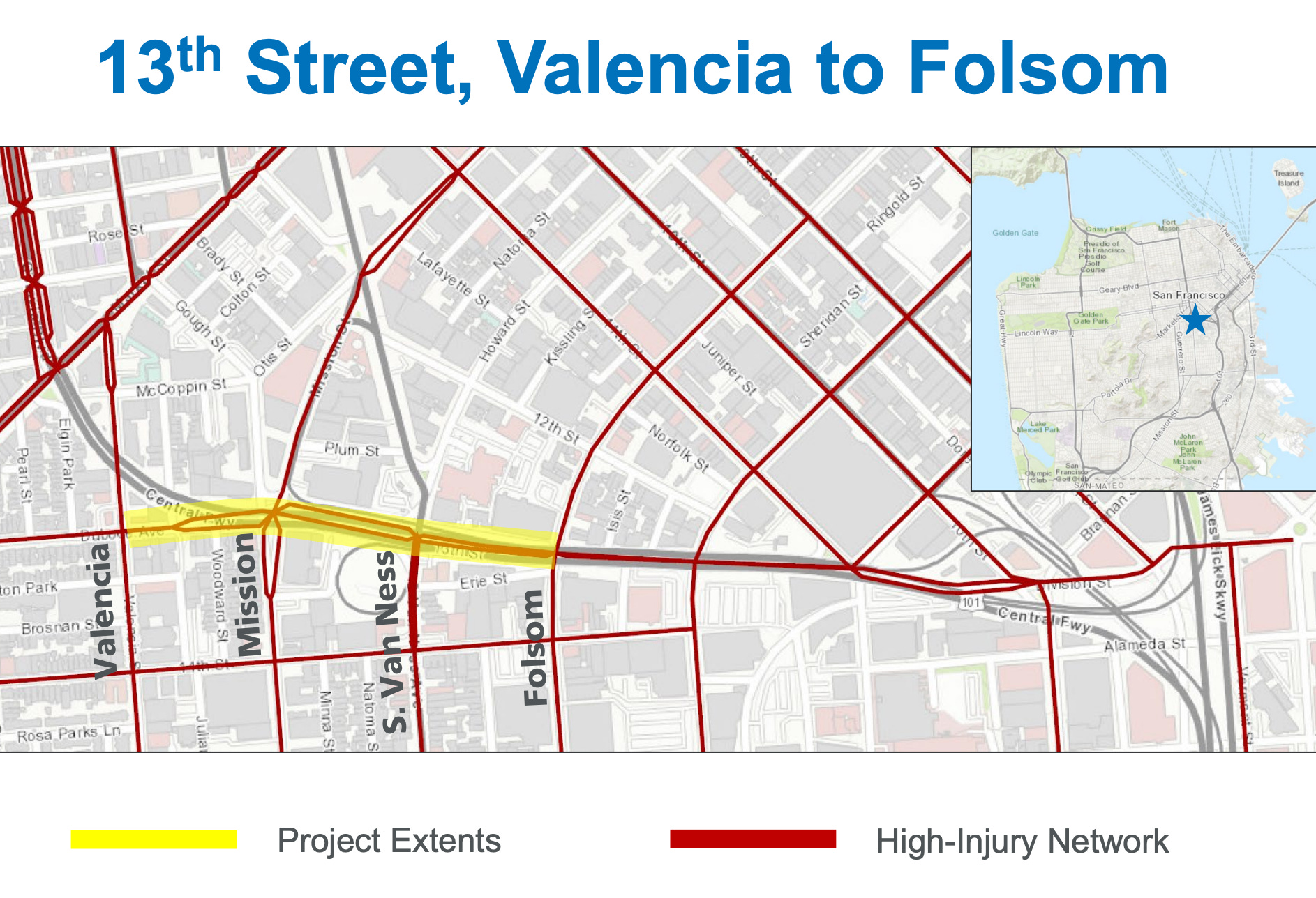
The project scope is from Folsom to Valencia along Duboce/13th Street. One lane of vehicle traffic will be removed in both eastbound and westbound directions in order to make room for bike lanes, plus other significant changes. The project is “only” three blocks long, but it comes with an estimated $9M price tag and has much larger implications for everyone.
(One side note for those not familiar with this area: The street in question is named “Duboce Avenue” west of Mission and “13th Street” east of Mission Street. This is one street with two names which are often used interchangeably.)

Image: Bike Lanes and more traffic restrictions are coming soon to Duboce Avenue / 13th Street between Valencia and Folsom - including the areas around the 101 freeway on ramps and off ramps!1
Project Justification: Safety + Bike Network
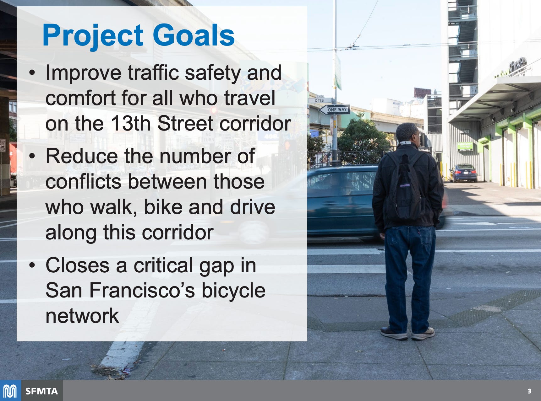
The project’s stated aims are to:2
- Improve traffic safety and comfort for all who travel on the 13th Street corridor between Folsom Street and Valencia Street
- Reduce the number of conflicts between those who walk, bike, and drive along this corridor
- Increase the connectivity of San Francisco's bicycle network
In short, the project intends to increase the volume of bicycles while reducing conflicts with vehicles. This is on a stretch of road that includes freeway on/off ramps.
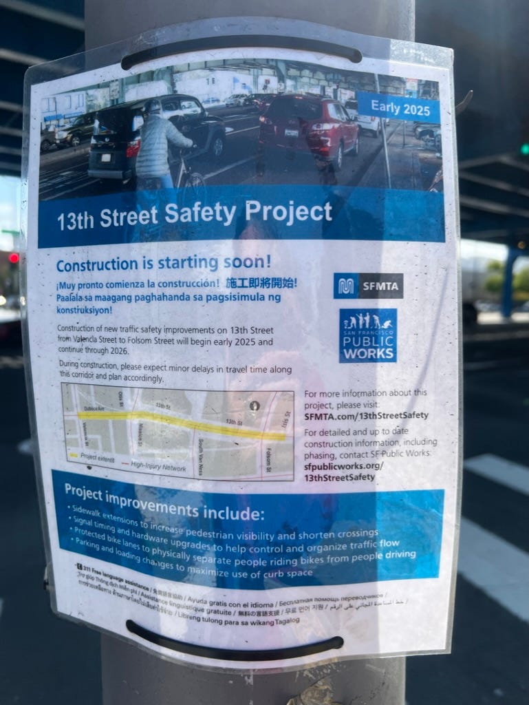
Image: Official notice for the project at the corner of 13th and Harrison.
Analysis of Traffic Volumes: 27 Bicycles!
According to the traffic analysis included in the related engineering report, combined volumes at the intersection of 13th and South Van Ness for the morning and evening peak hours were counted as:
Vehicles: 7,367
Bicycles: 27 (Yes, twenty seven bicycles. This is not a typo.)
Pedestrians: 210
The traffic report is dated 24 March 2021.3 For those who need a history lesson refresher - at that time a large percentage of the businesses in the San Francisco Bay Area were still operating with work from home mandates. The traffic volumes during “normal” conditions would almost certainly be much higher but are not considered in the engineering report or the related SFMTA staff report.
If only 27 bicycles were counted here at peak rush hour, how is a bike lane project actually justified?
The SFMTA notes that one of the objectives of the project is to connect the bicycle network - which suggests that the intention is to increase the volume of bicycles traveling through the area. But how is this consistent with the other stated objective to reduce the number of conflicts between cars and bicycles?
Summary of Planned Changes
The planned changes cover several pages of text and are worth a read in detail. High level the changes from Valencia to Folsom Street on Duboce / 13th Street include:4
Remove one lane of traffic in both directions
Add new protected bike lanes in both directions
Remove at least 33 parking spaces
Widen sidewalks
Traffic signal and lane changes including new no right turn on red restrictions and no left turns at many intersections
New pedestrian sidewalk and traffic signal at the freeway onramp at South Van Ness
and more….
The SFMTA Staff Report asserts “Based on traffic analysis using traffic counts prior and during the COVID-19 pandemic, the proposed travel lane reductions will continue to accommodate peak hour traffic.”5 How did the author staff report arrive at this conclusion? How is this not going to be catastrophic for commuters and businesses who rely on access to the 101 freeway?
NOTE: The related engineering report includes a very complicated analysis of existing and proposed traffic patterns which I honestly have difficulty understanding.6 Please add your interpretation of these charts and diagrams to the comments below.
New Pedestrian Crossing at Freeway on Ramp???
Please examine this plan and try to explain how this will improve safety from South Van Ness Avenue to the Central Freeway.

Image: Concept drawing included in documents for the 19 August 2022 SFMTA Engineering Hearing. 7 Also included in October 2022 SFMTA staff presentation slide deck. 8
The image above shows parked cars at the center of the 101 / Central on ramp circle from South Van Ness Avenue. Since that photograph was taken, the parking lot has been converted to a Navigation Center which provides services for the local homeless population, including 186 beds for overnight accommodation. The Navigation Center is surrounded by a fence with the only entrance on 13th Street.

Image: Start of the onramp to the 101/Central Freeway from South Van Ness Avenue9
Today there is no pedestrian access on the west side of South Van Ness south of the intersection with 13th Street. The planned changes will introduce a new sidewalk along the side of the freeway entrance. How is encouraging pedestrians to be closer to the freeway possibly going to improve safety?
In addition, today once vehicles clear the South Van Ness / 13th Street intersection they travel freely onto the 101 on ramp without obstruction. The plan shows a new traffic signal for a new pedestrian crossing at the start of the ramp. The future adverse impact to the flow of traffic should be obvious to anyone reading the plan.
New Bike Lane across the 101 off ramp at Duboce?
Similarly, the proposal for the bike lane intersection with the Central Freeway 101 offramp for Duboce at Mission requires a closer look:
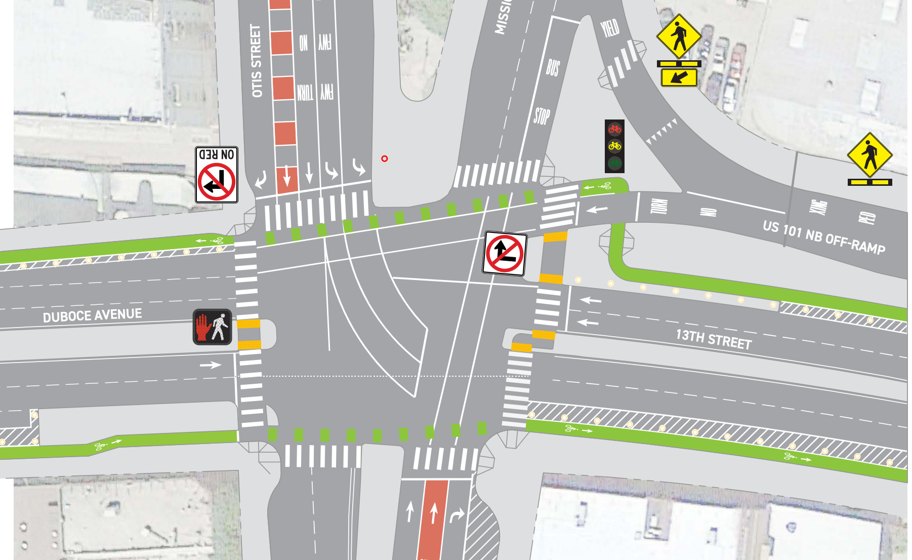
Image: Concept drawing for Bike Lanes at Central Freeway offramp at Duboce and Mission dated 2019.10
This is the freeway off ramp I take every day on my evening commute, so I know it well.
The traffic light for westbound Duboce at Mission is for both the vehicles exiting 101 traveling west as well as the two lanes of moving traffic from westbound 13th Street. The next block between Mission and Valencia is chaotic as many cars from the 101 exit are jockeying to move to the left lanes and many cars from 13th Street are trying to move into the right lanes. Cyclists traveling east on 13th Street generally join the melee - crossing from the right side of 13th Street across the 101 off ramp traffic to then be on the right side of Duboce heading towards Valencia. Every time I see a cyclist attempt this maneuver, I am terrified for everyone at this intersection.
I agree that this is a dangerous intersection. I disagree with the planned change.

View of westbound Duboce while standing on the pedestrian median between the 101 offramp (to the right) and 13th Street Westbound traffic (to the left).11
The plan is for the bike lane to direct cyclists to cross the 101 off ramp at the pedestrian crossing. The diagram suggests that there will be structural barriers to prevent cyclists from simply continuing with the flow of traffic west. If cyclists actually follow the direction of traffic, this would be a safer intersection. They could do so today by simply turning right at Mission onto the pedestrian island, crossing with the pedestrian light north on Mission, then waiting for the next light to cross westbound to Duboce.
This is theoretically possible, but I have never seen a cyclist do this in my 10+ years of using this freeway off ramp for my daily commute.
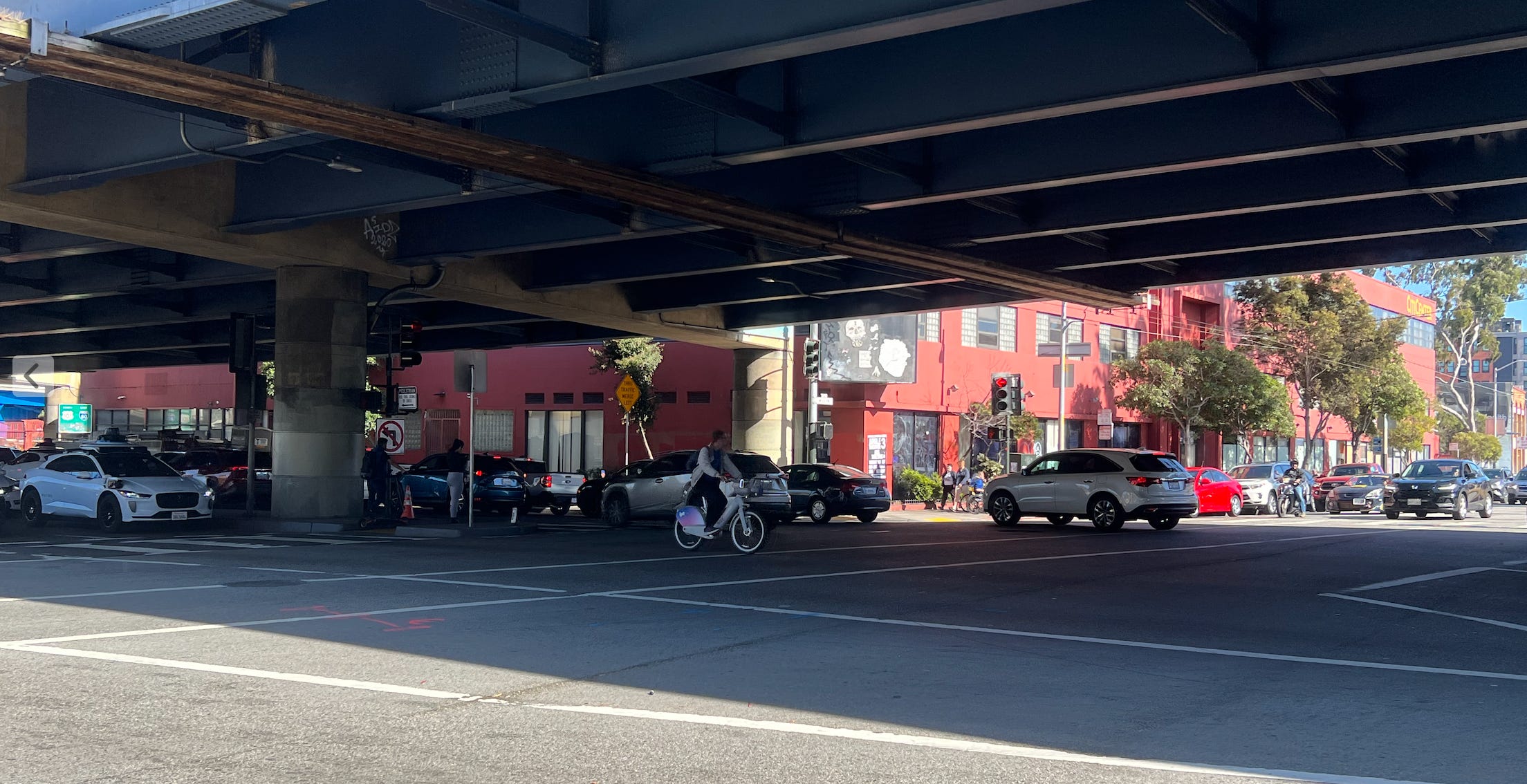
Image: Cyclist (without helmet) traveling on westbound 13th Street just before turning south onto Mission.12
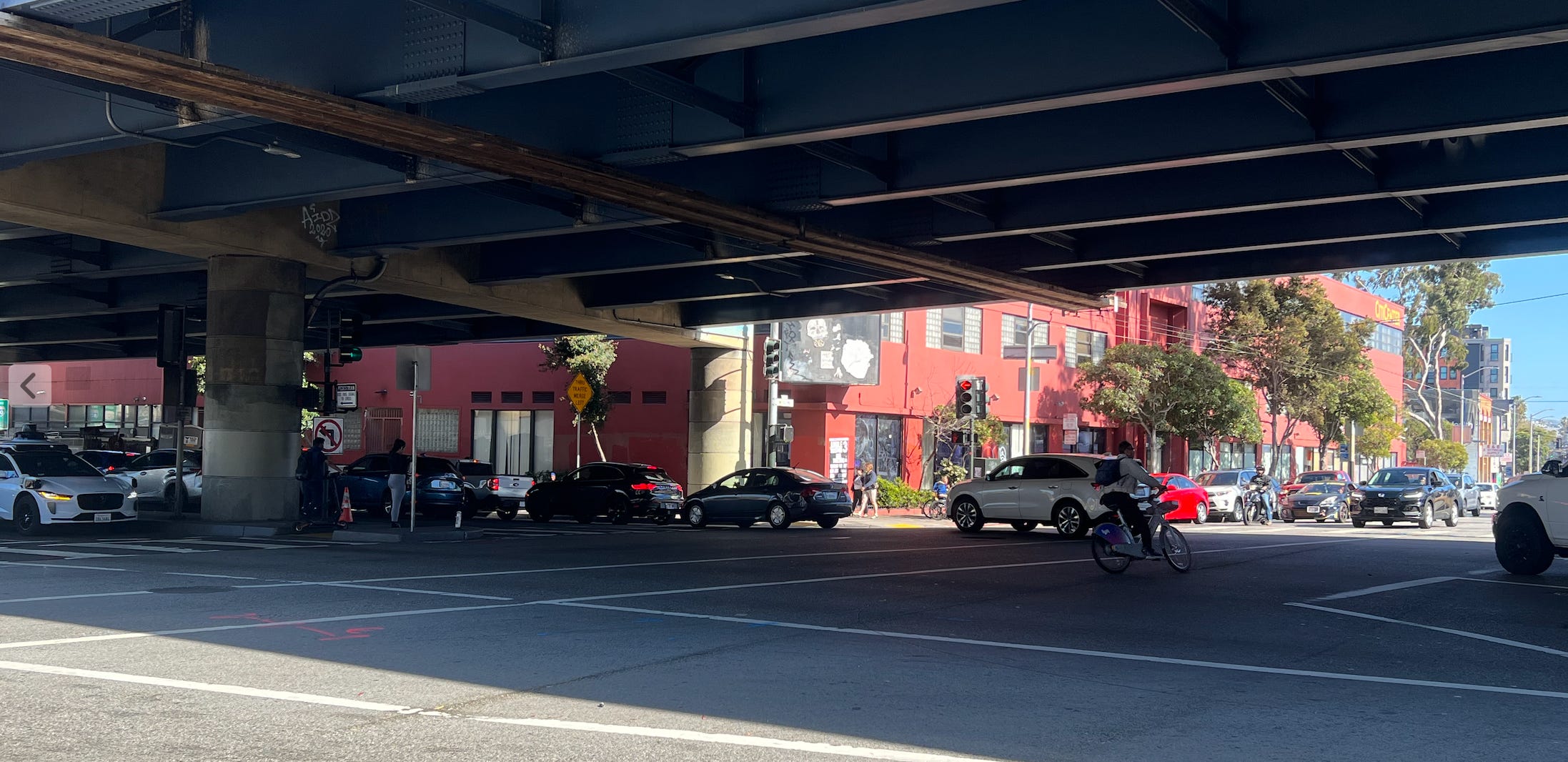
Image: Moments later, the cyclist turned south from 13th Street onto Mission Street through incoming eastbound traffic.13
What about Existing Bike Lanes on 11th and 14th Streets?
If the project truly is focused on safety and reducing conflicts between bicycles and vehicles, why doesn’t the SFMTA explore alternatives to redirect the cyclists away from this area toward other possible routes to Valencia?
Eastbound Cycling Route: Today there is an existing bike lane one block away on 14th Street traveling eastbound from Market to Harrison. The route on 14th Street was specially designed for cyclists as a “green wave” street as a one way eastbound street with traffic signals optimized for cyclists travelling at 13 mph.
Westbound Cycling Route: Cyclists traveling west from Harrison Street can use existing bike lanes from 11th Street to Valencia via Mission, Otis, and McCoppin.
Both bike routes connect with Valencia Street literally one block away from Duboce - 14th Street is one block south and McCoppin Street is one block north. With the exception of the two blocks on Mission and Otis, both alternate routes have relatively low current traffic volumes compared to Duboce/13th Street.

Image: Existing nearby bike routes include eastbound 14th Street (base of triangle) and 11th Street (right side of triangle). 11th Street connects to Valencia and Market through Mission, Otis and McCoppin.14
The SFMTA’s Staff Report acknowledges the existence of nearby bike routes but dismisses these as inadequate with the following explanation.
[The proposed] “Class IV bikeway (protected bikeway) is preferable to a Class II bikeway as it offers upgraded protection for people traveling by bike and limits their exposure to moving vehicular traffic. Also, eastbound bicycle facilities on 14th Street end at Harrison Street.”15
The report fails to note that before the “end” of the 14th Street and Harrison cyclists can turn left onto an existing bike lane at Folsom, which connects to the eastbound bicycle network at 13th Street.
If existing bike routes one block away are considered to be inadequate, then the message is clear - every street in San Francisco is a potential target for a new bike lane, even those which are critical for freeway access.
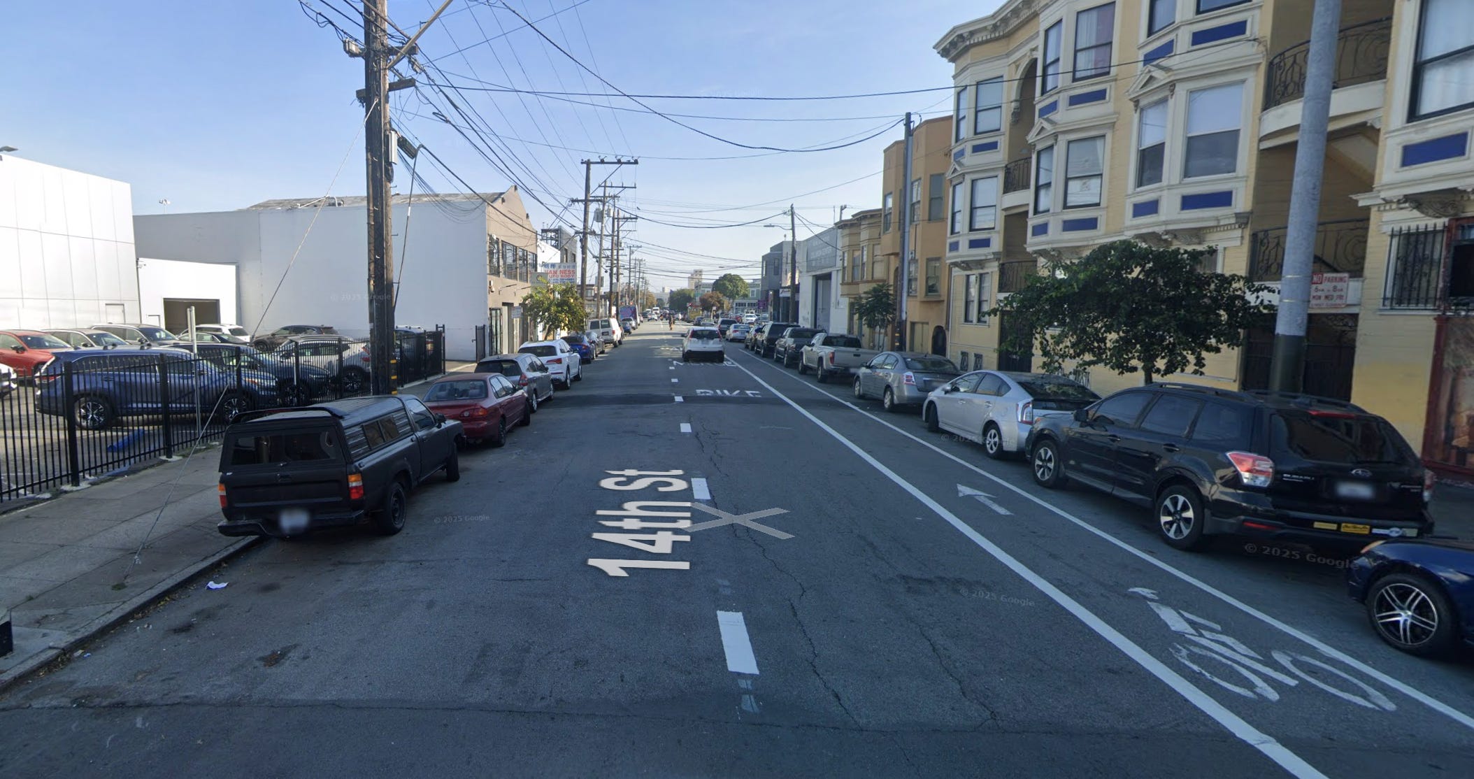
Image: 14th Street looking east from South Van Ness Avenue16
Coming Soon: More Traffic Congestion
Today, as vehicles travel west on Duboce from Mission, two lanes from 13th and one lane from the freeway offramp continue as three lanes of traffic on Duboce through to Valencia. At any hour day or night the cars coming off the 101 Freeway at Duboce must wait several cycles of traffic lights before they can clear the intersection.
Often there are a few drivers who try to get across the intersection during the yellow light but are unsuccessful - blocking traffic for the south bound traffic on Mission. With the planned changes, the westbound segment of Duboce from Mission to Valencia will be reduced to two lanes.17

Image from 19 August 2022 SFMTA Engineering Public Hearing Slide Deck, page 38
This will certainly increase the queue length and travel time to clear the Mission street intersection for vehicles taking the Duboce exit from the 101 and increase the probability of frustrated drivers blocking the intersection.
Similarly one lane of traffic will be removed eastbound on 13th from Mission towards South Van Ness. Traffic regularly snarls here today when traffic bound for the 101 onramp fail to clear the intersection at Mission and 13th. With one less lane of traffic and the additional traffic light at the freeway onramp, this intersection is going to become even more frustrating for everyone - including those taking the very popular Muni Bus Route #14 on Mission Street which crosses 13th.
Of course, this is only my assessment. According to the SFMTA planners, concerns about increased congestion are unwarranted.
Video: Traffic driving eastbound on 13th Street during evening rush hour on 20 May 2025 and related congestion. The #14 Muni bus is attempting to drive north on Mission Street.18
Sidewalk Widening and Reducing?
Another component of the 13th Street Safety Project is sidewalk widening. The project documents state that the sidewalk on the north side of 13th Street between South Van Ness and Mission is “inadequately wide”. 19
While it is factually correct that this section of sidewalk is narrow, the next question needs to be “is this a problem?” and “what are possible solutions?” If safety is truly the goal, then shouldn’t the SFMTA try to route pedestrians away from this traffic?
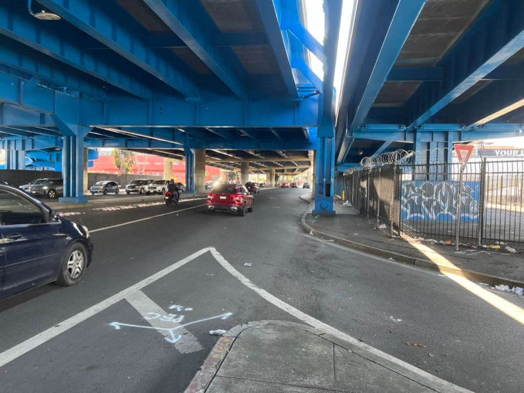
Image: View of westbound 13th Street from South Van Ness Avenue.20
And then continuing along 13th street towards Mission the sidewalk is deliberately narrowed by the city with a chain link fence.
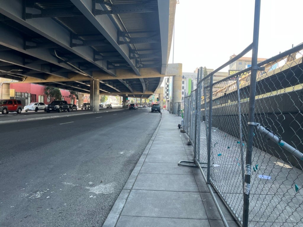
Image: View westbound 13th Street approaching Mission Street.21
Until recently this area was filled with homeless encampments. The chainlink fence is a relatively new installation. If homeless encampments start to build out in this new wider sidewalk area protected from the elements by the Central Freeway overhead, will the City then install a fence to deter the homeless encampments?
In short, San Francisco taxpayers are simultaneously funding efforts to widen the sidewalk as well as to reduce sidewalk access on the same block of 13th Street.
Did I mention yet that this project comes with $9M price tag at a time when the City is running an estimated $800M deficit? But even if the City were flush with money, the project still is an extremely bad idea.
Project Timeline and Outreach
I first learned about this project recently when I spotted one of the SFMTA’s blue notice posters at the intersection of Harrison and 13th Street. I thought this would be a notice about an upcoming hearing for proposed street changes and was surprised to see that it was a notice about the start of construction. For a project this significant, I had expected to hear of it at a much earlier stage.
My findings for the timeline and outreach for the project are detailed in the footnotes.22 In summary, the project origins date back to at least 2019. In 2021 the SFMTA began to engage directly with “stakeholders”, including the San Francisco Bicycle Coalition and Walk San Francisco.
Was the average commuter who relies on access to the Central Freeway at Duboce aware of this project before now? I certainly wasn’t.
SFMTA Board Meeting
The SFMTA Board approved the project at their 18 October 2022 meeting. I encourage everyone to listen to the related recording as it is very educational regarding the mindset of the SFMTA Staff and Board.23
Jamie Parks, SFMTA Director of Livable Streets, opened the presentation with the statement “safety improvements are at the very core of our vision zero strategy.”
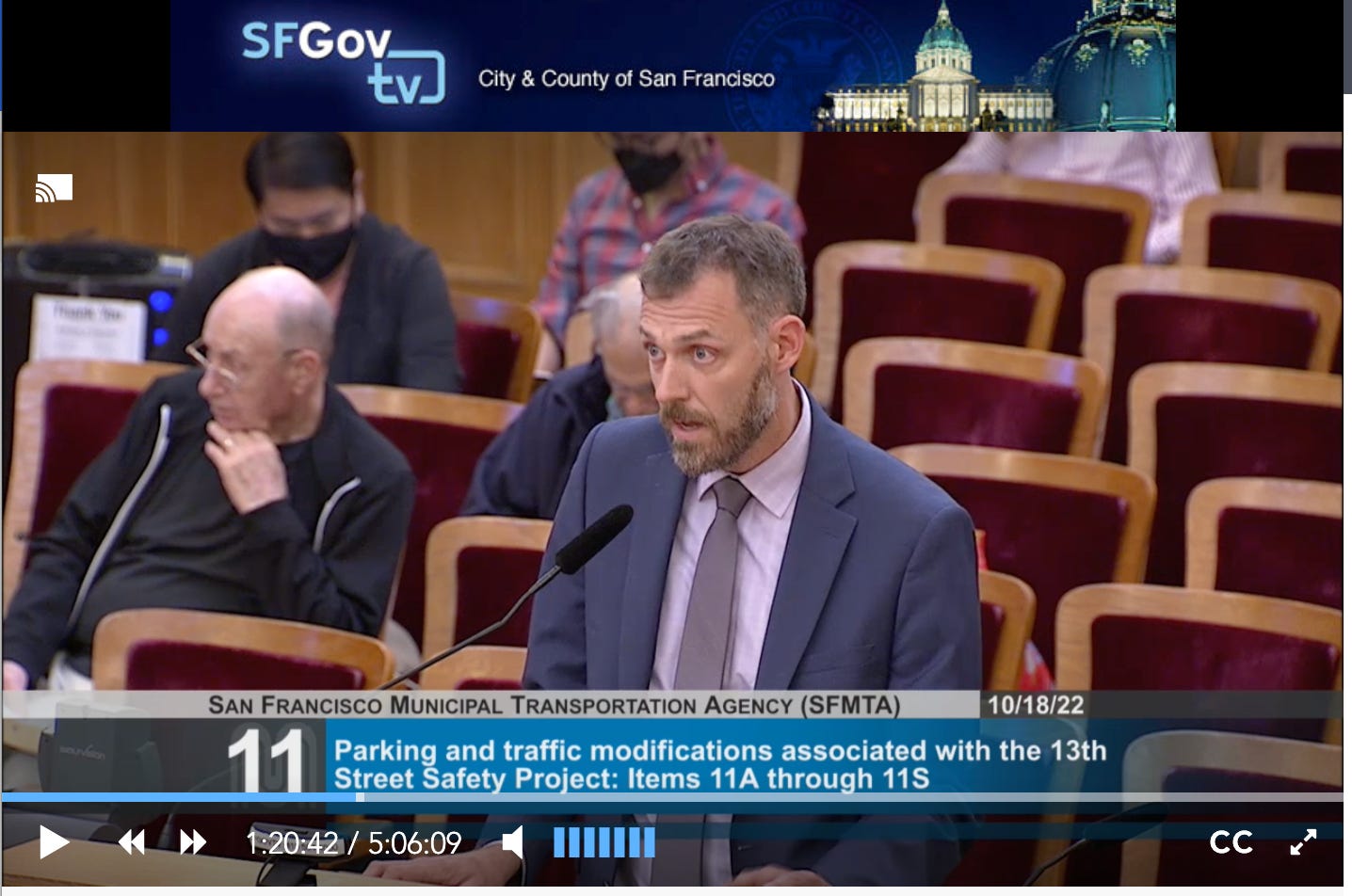
Mr Parks raised his call to action for the project. “The last three blocks of 13th street remain a stubborn gap in the bike network to connect SOMA to the Mission." He did not acknowledge the bike lanes that exist today literally one block away both north and south of Duboce/13th Street.
SFMTA Planner, Jennifer Wong, presented the project and related designs to the SFMTA Board. As Ms Wong showed the below map she called out that the project area is part of the San Francisco High Injury Network - “the 13% of streets in San Francisco which disproportionately account for 75% of all severe and fatal collisions in San Francisco.”
Ms Wong explained the project goals as focused on safety and closing a critical gap in the bike network.24
The SFMTA staff presentation and related SFMTA Board discussion did not ask or answer any of the following questions:
How is increasing pedestrian access to the Central Freeway on ramp a safety feature?
Why is this bike lane project needed given there are existing bike routes one block away and the related traffic study found only 27 bicycles and 7,367 vehicles are utilized the intersection of South Van Ness and 13th Street in March 2021?
Are we confident that the outreach efforts have reached a representative sample of those who will be directly impacted by the proposed changes?
What is the expected additional travel time for commuters, visitors, and others who are using the Central Freeway on ramp/ off ramps at Duboce and 13th and what is the related anticipated economic impact of these changes San Francisco residents and businesses?
How would you answer any of these questions?
Public Comments were 100% Opposed to the Plan
During the SFMTA staff presentation, Ms Wong stated that the public feedback for the project has been overwhelmingly positive to date. At the 18 October 2022 SFMTA Board Meeting, three people raised public comment against the project. Zero people spoke up in favor.
Two of the individuals who opposed the project self-identified as San Francisco taxi drivers. Please listen to their comments from the 1h54m40s point in the video.
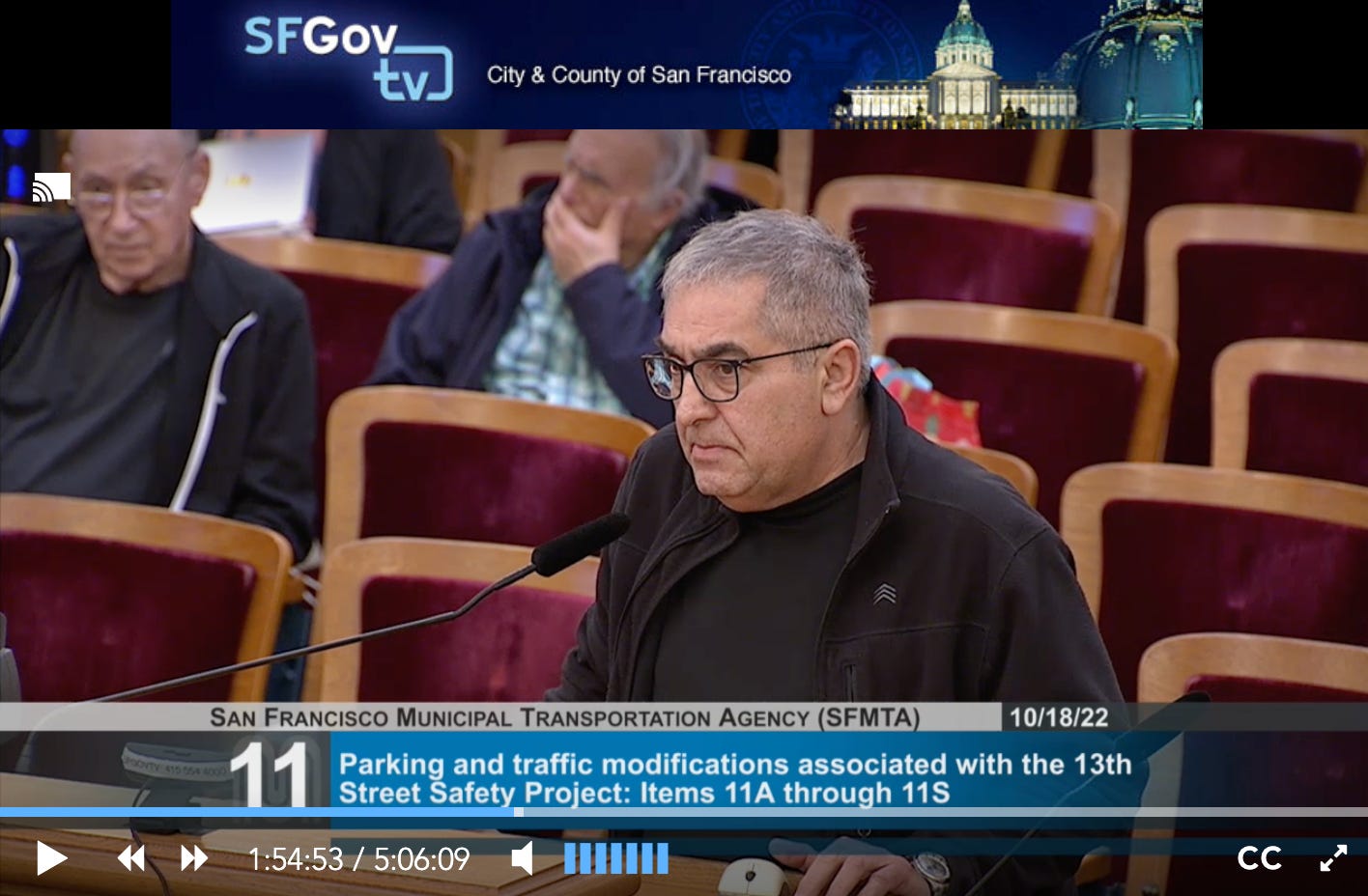
The speaker above stated that he has been driving a taxi cab in San Francisco since 1984. Key points from his comments include:
I am talking about the "silent majority. Because of their planning they have made traffic more difficult. They have destroyed businesses on Mission Street as well as other parts of the city.
He continued:
They are supporting the ideas of a bunch of radical people in San Francisco by putting lot of bicycle lanes everywhere. I don't think that the business community has spoken enough about this disaster.
Another caller stated his perspective as:
This is not traffic engineering. This is social engineering.
Notably absent at the SFMTA hearing were representatives of the San Francisco Bicycle Coalition. Given that the central focus of the project is the extension of the San Francisco Bicycle Network, why were they not present and offering comment?
Logically, one of the following must be true:
The SFBC was unaware of the hearing.
The SFBC was aware of the hearing but chose not to participate because they did not see this agenda item to be relevant to their members and stakeholders.
The SFBC was aware of the hearing and viewed this to be relevant to their members and stakeholders, but chose not to participate because they did not expect any meaningful opposition to the proposed bike lanes.
Other???
Why do you believe the SFBC did not participate in public comment for the related SFMTA Board Meeting?
What’s Next?
In the absence of any civilian uprising or sudden awakening by the San Francisco City Government, the SFMTA’s plan will continue to be implemented. Heavy machinery is already in place on 13th Street near Folsom.
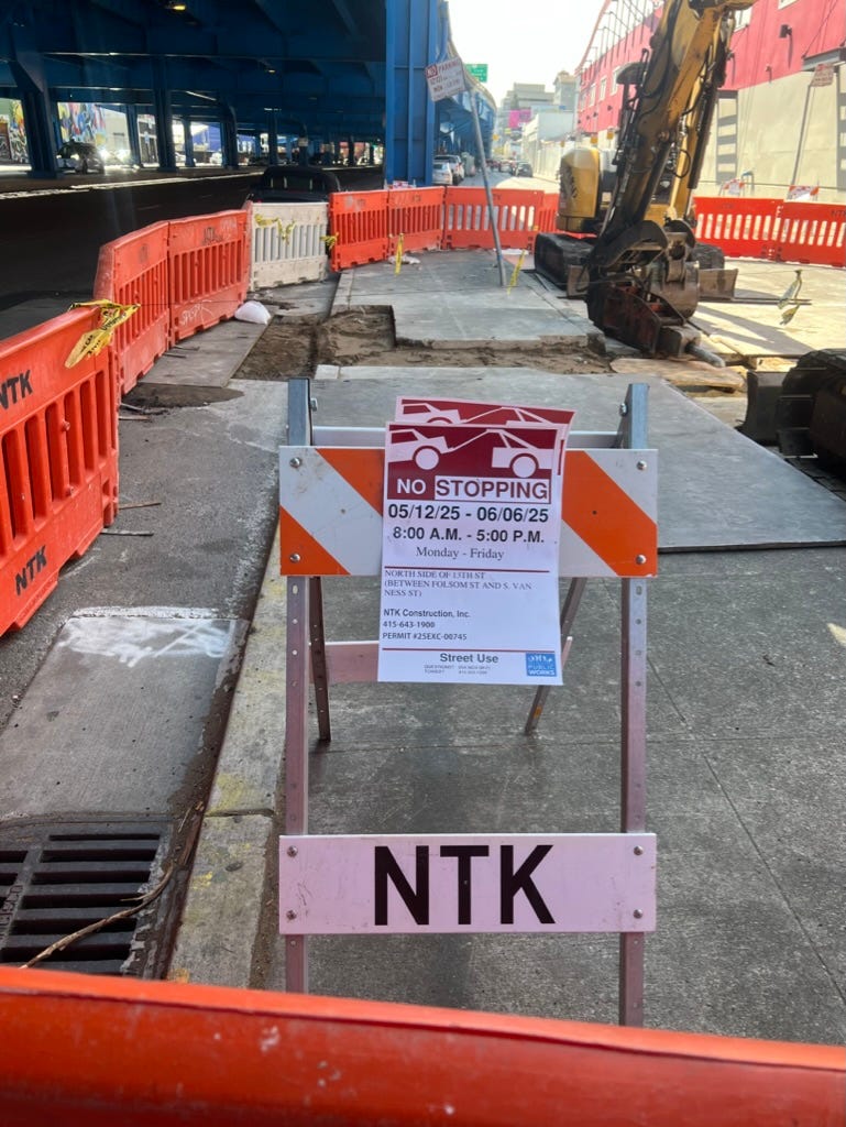
Image: Heavy machinery on 13th Street near Folsom and related notices for NTK Construction Inc, May 2025.25
How does this relate to the Bike and Roll Plan?
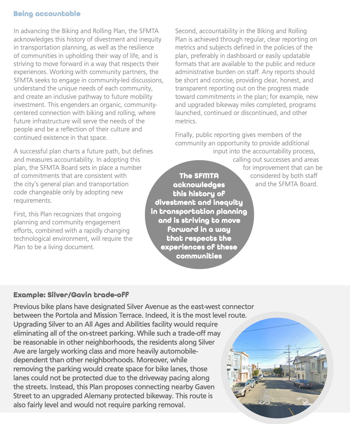
In March 2025 the SFMTA approved the Bike and Roll Plan - aka the 15+ year plan for the San Francisco Bicycle Network. The Bike and Roll Plan states that the bicycle network plans will be adjusted according to local business and resident requirements. It calls out an example of how the original plan for a bike lane on Silver Street would have been destructive to on street parking serving local businesses but the SFMTA wisely chose to implement the bike lane elsewhere.26
Is the SFMTA actually following the guidance of the Bike and Roll Plan to assess impact to local communities for their plans and find alternate routes?
Future Bike Lanes on Duboce to Market?
The Bike and Roll Plan proposed future bicycle network includes bike lanes from Folsom through to MARKET street on Duboce. I actually noticed this when reviewing the detailed map of the Bike and Roll Plan but dismissed this as future and aspirational and something that sane people of San Francisco would object to. Therefore my original analysis of the Bike and Roll Plan did not report this crazy idea.
No more. Apparently no traffic artery in San Francisco is safe from the SFMTA’s plan to expand bike lanes everywhere. I haven’t had a chance to research if this stretch of Duboce has already been approved for bike lanes, but in any case, anyone who cares about the future of our city needs to speak up.
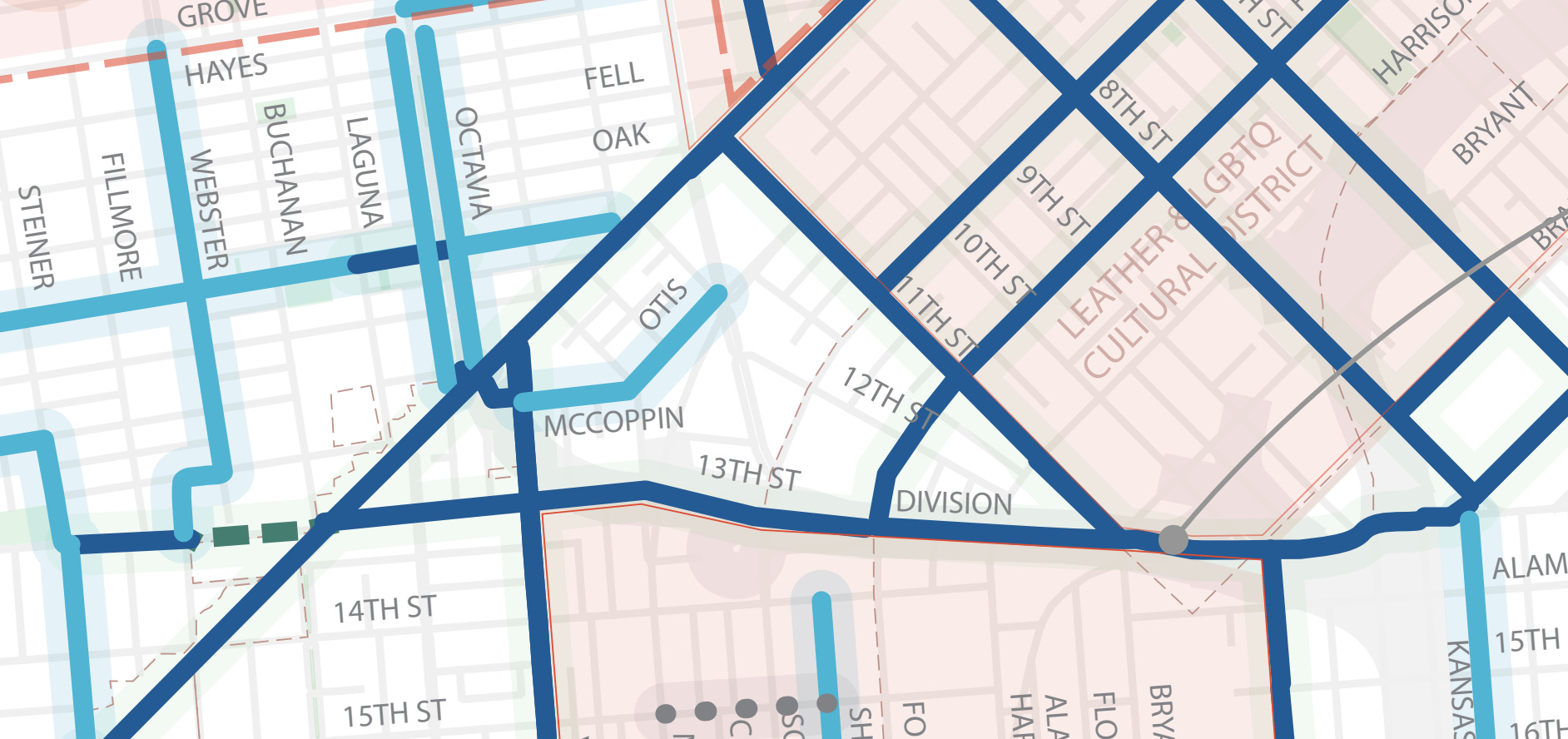
Image: San Francisco Bike and Roll Plan Northstar network.27
And again (at the risk of being repetitive) - there is an existing bike lane eastbound on 14th Street to Folsom and an existing bike route connection from Folsom to Market westbound via 11th street. Bike routes exist on adjacent streets to this primary corridor that serves commuters and visitors to and from San Francisco. The Bike and Roll plan does not consider Class II Bike lanes to be part of the Bicycle Network therefore 14th street and the connection from 11th street to Valencia and Market are excluded from the above plan.
The SFMTA’s current Bicycle Network Map, however, does make it clear that there are existing Bicycle route connections from Folsom to Market Street.

Image: Existing nearby bike routes include eastbound 14th Street (base of triangle) and 11th Street (right side of triangle). 11th Street connects to Valencia and Market through Mission, Otis and McCoppin.28
Speak up now! Where is the “Silent Majority”?
I encourage everyone to read the full documents and watch the videos of what I have linked so you can make your own conclusions about the traffic modifications now underway on 13th Street and Duboce. Please include your own thoughts in the comments.
But most importantly, please do speak up to the San Francisco City Government. To date the vast majority of voices heard by the SFMTA have been in favor of this project. Is that representative of the wider community of residents and businesses in San Francisco?
The taxi driver who spoke at public comment at the 18 October 2022 meeting said that he was speaking on behalf of the silent majority. Was he correct?
How to speak up:
The above button is a link to a Jotform. You can customize the message to reflect your perspective. The form will generate emails to Mayor Lurie, the SFMTA Board, the 13th Street Project Staff.
SFMTA Board Meetings are every two weeks on Tuesdays at 1pm at SF City Hall, 4th Floor, room 400. Please come and make public comment at the beginning of ANY and EVERY meeting. Next meeting is Tuesday 3 June 2025.
Send public comment to the SFMTA here:
MTABoard@sfmta.com - SFMTA board’s email address
13thStreetSafety@SFMTA.com - project email address
Let Mayor Daniel Lurie know what you think.
email - daniel.lurie@sfgov.org
Share your thoughts this topic on your favorite social media platform. Please include a link back to this original article.
Let me know in comments other ways to provide feedback and I will add below.
Please Share and/or Subscribe
I am committed to always offering my substack for free to everyone. I am trying to figure out how to accept voluntary donations without requiring a subscription.
If you appreciate my content, please subscribe and share and consider making a donation in the future once I figure things out.
Screenshot of live traffic conditions on Duboce and the related 101 on ramps/off ramps according to Google Maps — Saturday 24 May 2025 at 12:40pm.
https://storymaps.arcgis.com/stories/51d159d810184cc78ce3ac7a55aadde4, Section: Overview
https://www.sfmta.com/media/32698/download?inline - page 126
https://www.sfmta.com/media/33113/download?inline - page 7
Documents for 9 August 2022 Engineering Hearing, page 164. This is an attachment to a memo dated 28 June 2019 titled “07/09/2019 Board Meeting: Adopt the SoMa Freeway Ramp Intersection Safety Study Phase 2 Final Report”
Credit: Google Maps Street View.
Documents for 19 August 2022 Engineering Hearing, page 162. This is an attachment to a memo dated 28 June 2019 titled “07/09/2019 Board Meeting: Adopt the SoMa Freeway Ramp Intersection Safety Study Phase 2 Final Report.” Note that the diagram in the image shows MORE traffic lanes on 13th Street than the final plan.
Photo is my own.
Photo is my own.
Photo is my own.
Credit Google Maps Street View.
Image from slide deck for 19 Aug 2022 SFMTA Engineering public hearing, page 38
Video is my own.
https://storymaps.arcgis.com/stories/51d159d810184cc78ce3ac7a55aadde4 - Section: Proposed changes
Photo is my own.
Photo is my own.
This is what I have pieced together regarding the project timeline and related outreach to date

(Image from Slide deck for 18 Oct 2022 SFMTA Board meeting. https://www.sfmta.com/media/33114/download?inline - page 14
The earliest references I have found to the proposed changes date to 28 June 2019 SoMa Freeway Ramp Intersection Safety Study Final Report. (Documents for 19 August 2022 Engineering Hearing, page 158. This is an attachment to a memo dated 28 June 2019 titled “07/09/2019 Board Meeting: Adopt the SoMa Freeway Ramp Intersection Safety Study Phase 2 Final Report”) This is the report features the bizaare proposal to add a sidewalk next to the Central Freeway where none currently exists in the name of “safety.”
Public outreach for the project began in Fall 2021 with a public survey and direct engagement with community stakeholders including the San Francisco Bicycle Coalition and Walk San Francisco. The SFMTA also sent mailers to 2,200 addresses in the project vicinity. (SFMTA Staff Report -page 12 )
From this point forward (if not earlier) those who are advocates for removing vehicles on the streets of San Francisco were directly engaged.
The outreach continued in Spring 2022:
Door to door outreach with merchants and stakeholders along the project corridor have occurred for the duration of the project. General public outreach was conducted in April 2022 through a virtual open house using StoryMaps was live for 2 weeks. 2 tabling events and 4 online office hours were also held during this time. Merchants also had a chance to fill out loading surveys and follow-up meetings were held multiple times with various stakeholders.” (Documents for 19 August 2022 Engineering Hearing, - page 6)
The SFMTA staff report summarized the 80 survey responses as being overall favorable but did acknowledge that some respondents expressed concerns about congestion due to lane reduction and reduced availability of parking. (SFMTA Staff Report -page 12 )
The SFMTA’s engineering hearing for the 13th Street Safety Improvement Project was held on 19 August 2022. (SFMTA Agenda item 23) Unfortunately, the engineering hearings are not recorded, so we have to rely on the SFMTA’s summary of the feedback received. (SFMTA 19 August 2022 Engineering Hearing Results - page 12)
Public Comments: Received dozens of emails in support and suggestions for additional treatments. Several comments in support and two in opposition received at public hearing.
Two people spoke up in opposition to the proposal. Is this because the plan is so great that the residents of San Francisco are united in support for the project? Or is this because the outreach efforts of the SFMTA staff failed to actually reach those who are directly impacted by the proposed project?
SFMTA Board Meeting 18 October 2022, Agenda Item 11. Starting time stamp 1h13m.
Photo is my own. The traffic notice indicates a permit for NTK Construction Inc, which is also the company who was awarded the contract for the 13th Street Safety Improvements Project. Therefore I can only conclude that the heavy machinery is here to begin work on the planned street modifications.
Bike and Roll Plan Final - March 2025 page 17
Bike and Roll Plan Final. - March 2025, page 35
San Francisco’s version of “thinking big” seems to be just imagining how much bigger we can make gridlock at every single intersection in the city and how much more money we can spend doing it.
With all the traffic heading in various directions, this intersection is already
panic inducing. How would adding more bicycles into the mix help?
There are a number of flat blocks in the area that would be better suited for bicycles….come on SFMTA - SF is not Amsterdam!